4. Frequently asked questions
Document version |
Date |
Authors |
|---|---|---|
1.0 |
2021-07-23 |
D. Čápová, P. Kramolišová, L. Kondrová, O. Moravcová |
Last update: 2021-07-23
More questions: egdi.metadata@geology.cz
Here is a pdf file of this FAQ pdf
4.1. Metadata URL for uploading data
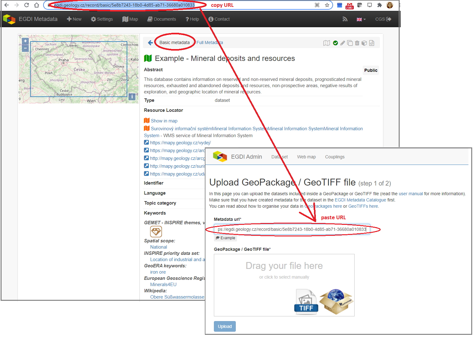
Question: I have tried to create a new EGDI metadata item, but I still don’t understand how I get the URL which is required to upload the actual data at the Admin modulehttps://egditest01.geus.dk/egdiadmin/geopack.jsp.
Answer: Requested URL is the URL on Basic metadata view of your record in the EGDI Metadata Catalogue.
For example, URL of example metadata record is:
https://egdi.geology.cz/record/basic/5e8b7243-18b0-4d85-ab71-36680a010833
See picture:
4.2. Inability to save metadata record
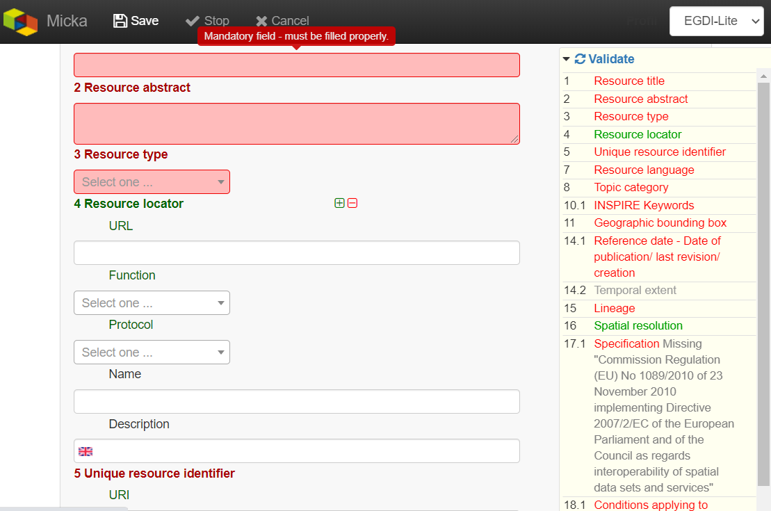
Questions: Why it is not possible to save the record in editing form?
Answer: The required fields highlighted in red are left blank (see picture below). You have to fill them in first, otherwise the record cannot be saved as it is described in the Cookbook (https://egdi.geology.cz/layout/egdi/MetadataCookbook_Lite.pdf) on page 15.
4.3. Metadata record not visible to all users
Question: Why is my newly created record not visible to my colleague?
Answer: Metadata status of this record is “Private”. Your colleague views the record as an unlogged user. To make the record visible to public, you must set the Status: “Public” and For viewing: “reader”. See picture:

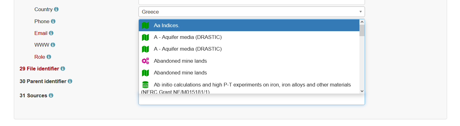
4.4. Search metadata by Project Name
Question: Why can´t I find my metadata in the EGDI Metadata Catalogue when searching by Project name keyword, for example “Mintell4EU” (picture below)?
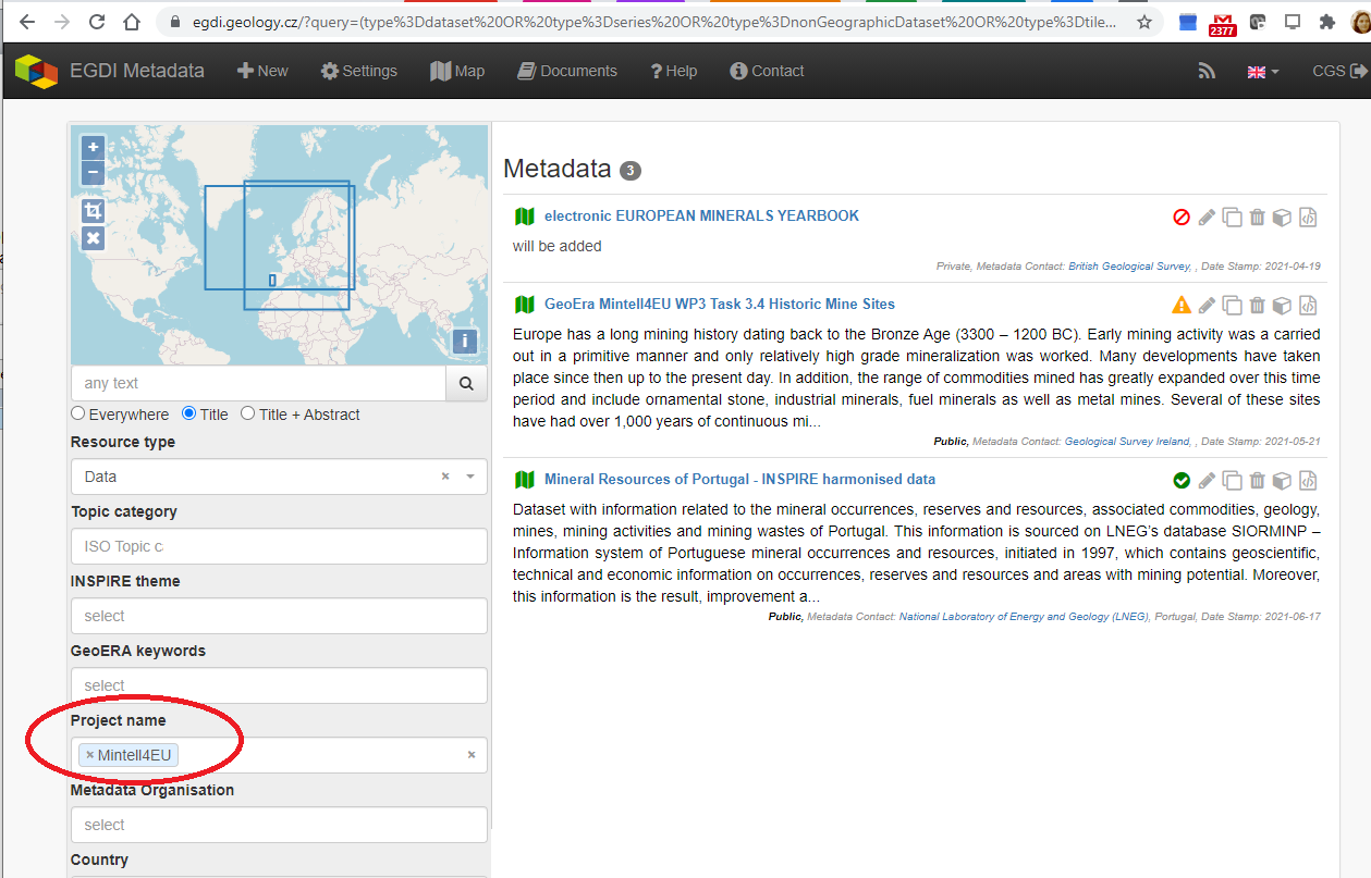
Answer: You did not enter the right project name keyword from the code list in your metadata record; you should select the appropriate Project name as a keyword from the list. See picture:

A common mistake is to include the project name as a Free keyword. After that, the record can only be found using the full text search.
4.5. Upload metadata from XML file
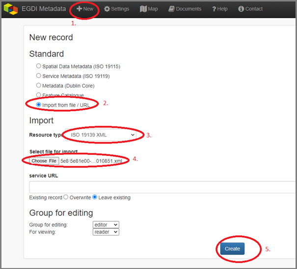
Question: Is it possible to upload metadata from XML file to the EGDI Metadata Catalogue?
Answer: Yes, of course, see picture below with steps 1. to 5. as red hints. The complete workflow is described in more details in the Cookbook (https://egdi.geology.cz/layout/egdi/MetadataCookbook_Lite.pdf) in the Chapter 3.1 on page 8.
Keep in mind that your xml file must meet international standards.
4.6. Use of example records
Question: Is there any example record for creating metadata? Can I use it as a template or to do a copy and edit it to create my own metadata record?
Answer: Yes, there are 3 examples:
Dataset example record:
https://egdi.geology.cz/record/basic/5e8b7243-18b0-4d85-ab71-36680a010833
3D model dataset example record:
https://egdi.geology.cz/record/basic/5e8b358e-7998-4f71-a363-2b260a010833
Service example record:
https://egdi.geology.cz/record/basic/5e8e29b8-e334-4b30-b78b-14750a010833
4.7. Unique resource identifier as URI
Question: Is there any recommended URI format for the Identifier (item 5 Unique resource identifier in the EGDI Metadata Profile) or is there any agreed convention for its definition?
Answer: There is no official standard other than formal URL rules, but it is our effort to define uniform rules in EGDI. For example Identifier as URI of harvested metadata from the Czech Geological Survey is as follows: https://registry.geology.cz/id/VDC-POD-WMS, where [https://registry.geology.cz/id] represents the domain, [VDC] represents the thematic database within CGS data store, [POD] represents the data set name, and [WMS] represents the type of access to the data set. For data which are available and uploaded to the EGDI Map Viewer it is recommended to begin the URI identifier with the EGDI domain: http://www.europe-geology.eu/id …..
Example URI: http://www.europe-geology.eu/id/mineral-resources/
4.8. Adding Web Map URL to the dataset metadata as an on-line Resource Locator
Question: I couldn’t find a link in my metadata record of dataset to see appropriate uploaded data on the EGDI portal. What should I do?
Answer: After uploading your data to the EGDI Map Viewer via the Admin module, return to your metadata record in the EGDI Metadata Catalogue. In the EGDI-Lite editing form add a link to the Service from the EGDI Map Viewer to the item “4 Resource locator” of the metadata record for related dataset. See picture below:

4.9. Linking of dataset metadata - Source Citation and Parent Identifier elements
Question: How to link aPan-European metadatarecord to national records?
Answer: It depends on how the related data layer is created and what the relationship should express.
The data relationship when “something is part of something else”. The resulting dataset is a superset with lower units - subsets (like a book with its chapters). In the subset record, select the higher item from the list in item 30 Parent Identifier.

The data relationship when “something comes out of/uses something”. The resulting layer is created by transforming or compiling other resources (modifying them, such as geographic or semantic harmonization). These resources must be identified by the item 31 Sources (list the sources citation). If the source metadata does not exist in the EGDI Metadata Catalogue, the URL of the external metadata in xml can also be entered in the field.
4.10. Metadata of a set of spatial products for one area
Question: If we upload a set of spatial products (e.g. temperature map, fault network, transmissivity map, etc.) covering the same area and coming from the same author/partner, does each single layer require a separate metadata entry or can we pool it for each set coming from the same author/partner, listing what the single layers are? For now, we applied the latter way, see the coupled resources (11 children / grandchildren) of https://egdi.geology.cz/record/basic/602f94c8-8bfc-42b6-a8a2-61070a010833
Answer: We think it is correct, see answer 9.1.
4.11. Validation of 3D models extended by vertical items compared to INSPIRE validation
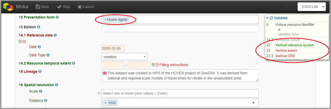
Question: Why validation panel requires vertical reference system and extent (item 22 and 23), when my metadata are 2D?
Answer:
As described in the Cookbook (https://egdi.geology.cz/layout/egdi/MetadataCookbook_Lite.pdf) on page 20, item 12 Presentation form, filled as value “Model digital”, is mandatory for 3D models. When selected from the codelist, the validation rules change to meet the metadata description requirements of the 3D models. You can also select the value “Model digital” for your 2D dataset, but then do not worry about validation of vertical items. This is only required for 3D models.
Didn’t find what you were looking for? Still have questions? Need help? Send us an email on: egdi.metadata@geology.cz